Where is Haiti located?
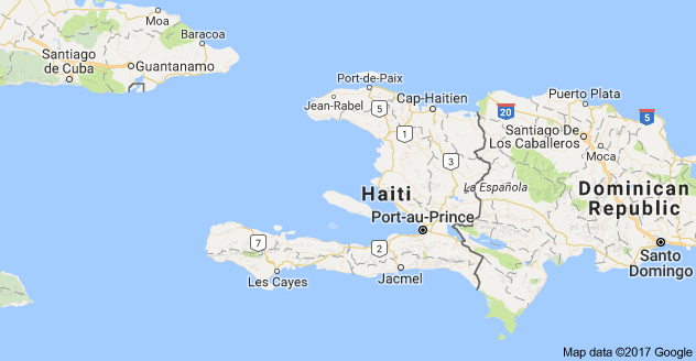
The country of Haiti, originally called “Ayiti” by the native Taino people, is a historic island nation that’s centrally located between the North Atlantic Ocean and the Caribbean Sea.
Haiti is also part of the larger island of Hispaniola, which it shares with the Dominican Republic.
The northwestern tip of Haiti is located just east of the Windward Passage, one of the busiest shipping lanes in the world.
The shipping channel connects the economic powerhouse of the United States to the Panama Canal.
The Pearl of the Antilles
Haiti is part of an archipelago known as the Greater Antilles.
The country was affectionately referred to as “The Pearl of the Antilles” for many years.
The Greater Antilles also include some of the Caribbean’s largest countries by both landmass and population.
Population of Haiti
As of 2020, Haiti has an estimated population of approximately 11 million people.
This makes Haiti the second most populated country in the Caribbean, preceded only by Cuba, with the Caribbean’s largest population of about 11.5 million people.
The population figure above may vary substantially based on the data source.
Because of how closely populated the Dominican Republic and Haiti are to each other, immigration trends, and other factors, the neighboring countries can sometimes have a population difference of less than half a million people.
Due to limited census data on the part of both countries, coming up with a conclusive population figure can prove to be a challenge.
Haiti Departments
The Haitian government is divided up nationally into 10 departments.
Most departments are named after their relative geographical location within the country.
For simplicity, you can think of the 10 departments as being 10 administrative regions, each with its own capital city.
The most populous and developed commune within a department is usually considered the local capital city of that department.
The 10 Departments of Haiti in alphabetical order are:
• Artibonite
• Centre (Center)
• Grand’Anse
• Nippes
• Nord (North)
• Nord-Est (North-East)
• Nord-Ouest (North-West)
• Ouest (West)
• Sud (South)
• Sud-Est (South-East)
Arrondissements
Each department in Haiti is divided up into multiple arrondissements.
Arrondissements are geographic districts within the department that administer a specific group of communes (major cities).
Communes
Communes in Haiti are typically considered the major cities within each arrondissement.
Likewise, each commune is then divided up into several communal sections.
Communal Sections
The communal sections in Haiti are all of the smaller towns, villages, and rural areas that make up a commune’s greater metropolitan area.
As of 2020, Haiti has 10 departments, 42 arrondissements, 145 communes, and 571 communal sections.
The overview above is simplified, but this is essentially how the Haitian government is administered on the national, regional, and local levels.